Cyclone Gulab: Hurricane Gulab raised concerns, Odisha started evacuating people, Orange alert in Andhra too
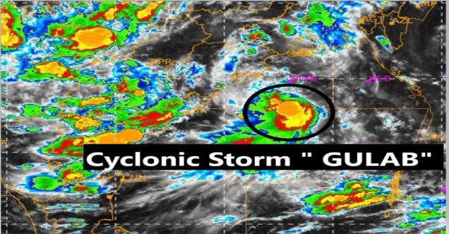
New Delhi. The low-pressure area over the Bay of Bengal has intensified into a cyclonic storm 'Gulaab' on Saturday. Pakistan has named this storm Gulab. According to the Meteorological Department (IMD), this storm will hit the coast this evening. During this time the wind speed can remain up to 85 kilometres per hour. An orange alert has been issued for the coastal areas of North Andhra Pradesh and adjoining South Odisha. Heavy rain may occur in these areas. Fishermen have been advised not to venture into the sea due to a heavy storm. At the same time, orders have been given to evacuate people from low-lying areas of Odisha.
Earlier in this season, two cyclonic storms have formed so far. The first cyclone Tout formed in the Arabian Sea, while the second cyclone Yas formed in the Bay of Bengal around 23 and 28 May. Let's take a look at where cyclonic storm Gulab is at present and which areas of Odisha and Andhra can cause damage…
Deep Depression intensified into Cyclonic Storm ‘Gulab’ over Northwest & adjoining west-central Bay of Bengal. Cyclone warning for north Andhra Pradesh and adjoining south Odisha coasts. It is likely to move nearly westwards and cross north Andhra Pradesh - south Odisha coasts. pic.twitter.com/4YFU71mHaQ
— Rising Odisha (@rising_odisha) September 25, 2021
Where has the storm reached at present: According to the information received till 11:30 pm on the night of 25 September, it is concentrated in the northwest and adjoining areas of the Bay of Bengal. At present, it is about 330 km east-southeast from Gopalpur in Odisha. Its distance from Kalingapatnam in Andhra Pradesh is 400 km east.
When will it landfall: It may hit the coast this evening. It is very likely to move almost westwards and cross North Andhra. It is being said that it may hit the coast between Gopalpur and Kalingapatnam.
The Cyclonic Storm ‘Gulab’ over northwest and adjoining westcentral Bay of Bengal moved nearly westwards lay centered at 2330 hrs IST of 25th Sep, over northwest and adjoining westcentral Bay of Bengal about 330 km east-southeast of Gopalpur & 400 km east of Kalingapatnam. pic.twitter.com/khk7TYnPQo
— India Meteorological Department (@Indiametdept) September 25, 2021
Wind speed: During the last 6 hours in the west of the Bay of Bengal, the speed of the storm has been 7 kilometres per hour. At the time of landfall, the wind speed can reach 85 kilometres per hour. According to Skymet Weather, due to the reduced sea travel of the storm, the wind speed will not be very strong.
Wind will prevail in these areas: Wind speed reaching 55-65 kph is likely over Andhra Pradesh's Srikakulam, Vizianagaram, Visakhapatnam districts and south Odisha coast (Ganjam, Gajapati district). Puri, Rayagada and Koraput districts will also be affected. Strong wind speed reaching 40-50 kph will prevail in the Malkangiri district of Odisha. Apart from this, the wind speed will be 85 kilometres per hour in many areas.
Heavy rain in these areas: According to Sky Met Weather, during the next 24 to 48 hours, there may be moderate to heavy rains at isolated places over South Odisha and North Andhra Pradesh. The most affected districts of Odisha can be Kendrapara, Jagatsinghpur, Cuttack, Bhubaneshwar, Khordha, Puri, Ganjam, Gajapati, Kandhamal and Raigad. In Andhra Pradesh, heavy rain with strong winds may occur in Srikakulam, Vizianagaram, Visakhapatnam, East Godavari, West Godavari, Guntur and Krishna.
Odisha started evacuating people,
while the Odisha government has asked seven districts to take high vigil. Special Relief Commissioner (SRC) PK Jena said the government has sent rescue teams to vulnerable areas and asked officials to evacuate people from low-lying areas.
Fire personnel along with 42 teams of Odisha Disaster Rapid Action Force (ODRAF) and 24 teams of National Disaster Response Force (NDRF) were sent to seven districts of Gajapati, Ganjam, Raigad, Koraput, Malkangiri, Nabarangpur, Kandhamal.


